
Amaravati Outer Ring Road – Information & Status
189 km Amaravati Outer Ring Road (ORR) expressway project by NHAI & APCRDA is a proposed 6 lane access-controlled road around Andhra Pradesh’s new capital city of Amaravati.
This 6 lane greenfield bypass will connect Vijayawada, Guntur, Tenali, and other areas. It is being planned as part of Andhra Pradesh Capital Region Development Authority (APCRDA)’s 2050 masterplan.
Amaravati ORR’s detailed project report (DPR) has not been published. Land acquisition hasn’t started for its construction. Its route will pass through 22 Mandals comprising 87 villages.
- Total Estimated Cost: TBD
- Project’s Total Length: 189 km
- Lanes: 6
- Status: DPR Preparation
- Deadline: TBD
- Owner: National Highways Authority of India (NHAI)
- Project Model: TBD
The project will be developed in two portions:
- Eastern-Half: 78 km
- Western-Half: 111 km
Design
Plans call for a 6-lane, controlled-access divided highway with 150 m RoW, three tunnels, nine interchanges and 2 bridges over Krishna River. It will link to all major Expressways, National Highways, State Highways, and to Machilipatnam Port.
Current Status
The project is currently in the proposal stage. Tender notices are pending for its construction work.
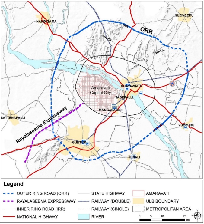
Route Map
Here’s Amaravati Outer Ring Road’s rough / indicative alignment from Japan International Cooperation Agency (JICA)’s report. Final alignment has not been prepared or fixed.
Amaravati Outer Ring Road’s official PDF route map showing its alignment will be added here when finalized and available.
Tenders & Contractors
This section will be updated when tenders are invited for its construction. The project is likely to be divided into 11 civil packages.
Page last updated: August 28, 2024. Have a question or spot an error? Let me know here.