
Bangalore Satellite Town Ring Road – Information & Status
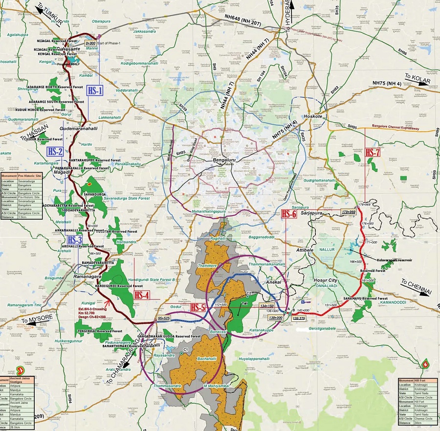
280.8 km Bangalore Satellite Town Ring Road (STRR, NH-948A) by NHAI is partly operational & under construction 4-6 lane access-controlled expressway with a route alignment in Karnataka connecting 12 towns of Dobbasapete, Doddaballapura, Devanahalli, Sulibele, Hoskote, Sarjapura, Attibele, Anekal, Tattekere, Kanakapura, Ramanagara and Magadi.
Prime Minister Narendra Modi inaugurated a 80 km section (Dobaspete – Hoskote) of Bengaluru Satellite Town Ring Road (STRR) on March 11, 2024. This comprises of 2 sections connecting Dobaspete – Doddaballapur Bypass and Doddaballapur Bypass – Hoskote.
This greenfield expressway under Bharatmala Pariyojna Lot-3 will serve as a bypass around Bengaluru city. It is being built in 3 parallel phases and involves construction of NH-948A and realignment of existing NH-648 (old NH-207).
STRR project has a deadline of December 2025. Its Detailed Project Report (DPR) was prepared by Louis Berger Group Inc. and KITKO (Hosur – Sarjapur section only). Land acquisition for the project started in 2018 with a total of 1009.8 hectares required in Karnataka and 340 hectares required in Tamil Nadu.
The expressway will serve as the eastern-end of the proposed 330 km Bangalore – Mangalore Expressway by NHAI. Its alignment will pass through Bannerghatta National Park (BNP)’s eco sensitive zone (ESZ) from Km. 95.525 to Km 138.0000 and includes a 8.1 km elevated highway through its core with a 28.50m ROW.
- Total Estimated Cost: Rs. 17,000 crore
- Project’s Length: 280.836 km (approx.)
- Lanes: 4 to 6 lanes
- RoW: 90m
- Design Speed: 100 kmph
- Status: Partly Operational (80 km) & Under Construction
- Deadline: December 2025
- Owner: National Highways Authority of India (NHAI)
- Project Model: Hybrid Annuity Model (HAM)
Route Map
An official PDF route map will be added here when available. Here’s a map from Louis Berger’s feasibility report:
Current Status
Bengaluru Satellite Town Ring Road (STRR)’s Packages 1 & 2 (Dobaspete – Hoskote) were inaugurated on March 11, 2024.
NHAI started collecting toll at Nallaru for Doddaballapur Bypass – Hoskote section (Package 2) in November 2023, and for the Dobbaspet – Doddaballapur Bypass section (Package 1) in June 2024.
Tenders & Contractors
Construction is being carried under 3 parallel phases consisting of multiple packages each with a 2 year deadline. 80 km Dobaspet – Hoskote section north of Bengaluru is early-bird and does not belong to any phase.
| Package (Distance) & Chainage | Contractor |
| Package 1 (42 km): 4 laning from Km 0.00 to Km 42.00 of Dobaspet to Dodaballapur Bypass section of NH-648 (old NH-207) | Shankaranarayana Constructions (SNC) |
| Package 2 (38 km): 6 laning from km 42.000 to km 80.00 of Dodaballapur Bypass to Hoskote section of NH-648 (old NH-207) | Dilip Buildcon (DBL) |
| Phase 1 – Package 1 (46.30 km): Obalapura (Nelamangala Taluk) to Somakkanamutta (Magadi Taluk) from km 0.000 to km 46.300 | Bids Re-Invited in Sept 2024 |
| Phase 1 – Package 2 (32.70 km): Somakkanamutta (Magadi Taluk) to Kunigal (Ramanagara Taluk) (Km 46.300 to Km. 79.000 | Bids Re-Invited in Sept 2024 |
| Phase 2 – Package 1 (33.60 km): Ramanagara to Bannerghatta National Park (Km. 79.00 to Km. 112.60) | Bids Re-Invited in Sept 2024 |
| Phase 2 – Package 2 (8.1 km): Bannerghatta National Park Elevated Highway (Km. 112.600 to Km. 120.700) | Bids Invited in Sept 2024 |
| Phase 2 – Package 3 (23.78 km): Bannerghatta National Park to Belagondapalli (TN) from Km. 120.700 to Km. 144.480 | Bids Re-Invited in Sept 2024 |
| Phase 3 – Package 1 (35.766 km): Balagondapalli (Tamil Nadu) to KA/TN Border (Km 144.170 to Km 179.936) | Montecarlo (MCL) |
| Phase 3 – Package 2 (20.9 km): 4 lane realignment of old NH-207 (new NH-648) from TN/KA Border (Km 0.000) to Hoskote (Km 20.900) | S&P – SIEPL JV (S&P Infrastructure Developers Pvt. Ltd. – Skylark Infra Engineering Pvt. Ltd. JV) |
Page last updated: September 7, 2024. Have a question or spot an error? Let me know here.