
Konkan Expressway – Information & Status
376 km Konkan Expressway (ME-6) by MSRDC is a proposed 6 lane access-controlled highway with a route alignment in Maharashtra connecting Panvel (Navi Mumbai) and Sindhudurg via Raigad and Ratnagiri.
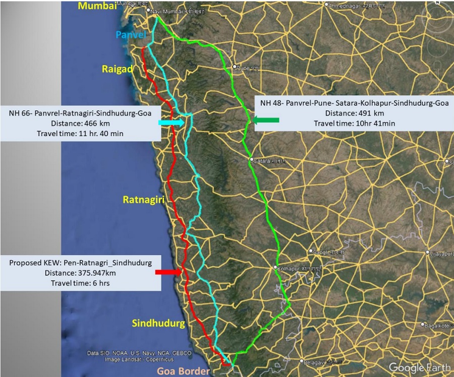
This greenfield expressway proposed by Maha Vikas Aghadi (MVA) government will run parallel to the Maharashtra coastline and connect 3 districts of Raigad, Ratnagiri, and Sindhudurg. The expressway is expected to reduce travel time between Mumbai and Sindhudurg to about 3 hours from the current 6-7 hours.
Konkan Expressway’s Detailed Project Report (DPR) is currently being prepared. Land acquisition is underway.
Key Details
- Total Estimated Cost: Rs. 68,720.03 crore
- Project’s Length: 376 km (approx.)
- RoW: 100m
- Lanes: 6 + 2 services lanes
- Design Speed: 150 kmph
- Status: Land Acquisition Underway
- Deadline: N/A
- Owner: Maharashtra State Road Development Corporation (MSRDC)
- Project Model: N/A
- Land Requirement: 4205.21 Hectares (1029.11 Ha. in Raigad, 2045.28 Ha. in Ratnagiri and 1130.81 Ha. in Sindhudurg)
Structure Details
- Minor Bridges: 49
- Major Bridges: 21
- Rail Overbridges (ROB): 3
- Viaducts: 51
- Tunnels: 41
- Vehicle Overpass (VOP): 68
- Vehicle Underpass (VUP): 45
- Interchanges: 14
- Toll Plazas: 15
- Wayside Amenities: 8
Current Status
Section 3 of Land Acquisition for Konkan Expressway has been submitted to the Government of Maharashtra, which will again be reworked as alignment is subject to change due to ESZ. Section 15 for Land Acquisition has been completed for package 1.
In August 2020, MSRDC invited tenders to prepare the project’s DPR in 4 sections (each 100-125 km long). Winners are unknown.
- Chirle Village (Panvel), Raigad Distict to Raigad/Ratnagiri District Border
- Raigad/Ratnagiri District Border to Guhargar-Chiplun (NH-166E) in Ratnagiri
- Guhargar-Chiplun (NH-166E) in Ratnagiri to Ratnagiri/Sindhugarh District Border
- Ratnagiri/Sindhugarh District Border to Patradevi on Maharashtra/Goa State Border
Route Map
An official PDF route map will be added here when available.
Konkan Expressway’s alignment passes through 232 villages of 17 taluks and 3 districts of Raigad, Ratnagiri, and Sindhudurg.
- The expressway’s northern terminal will be located at Shahbaj village on Package MMC-2 of the Virar Alibaug Multi Modal Corridor (VAMMC).
- From VAMMC, the expressway will following NH-66 near Shitole up to the Dharamtar Creek near Village Shahabaj. From there, it will deviate south servicing the Konkan belt.
- The alignment is being reworked for avoidance of Western Ghats Eco Sensitive Zone and a revised alignment will be submitted to the Government of Maharashtra for approval.
Konkan Expressway’s alignment is shown in Red below:
Tenders & Contractors
This section will be updated when tender notices for its construction are invited
| Package & Chainage | Contractor (Value) |
| Scope Unknown | TBD |
Page last updated: September 18, 2024. Have a question or spot an error? Let me know here.