
Gorakhpur – Siliguri Expressway – Information & Status
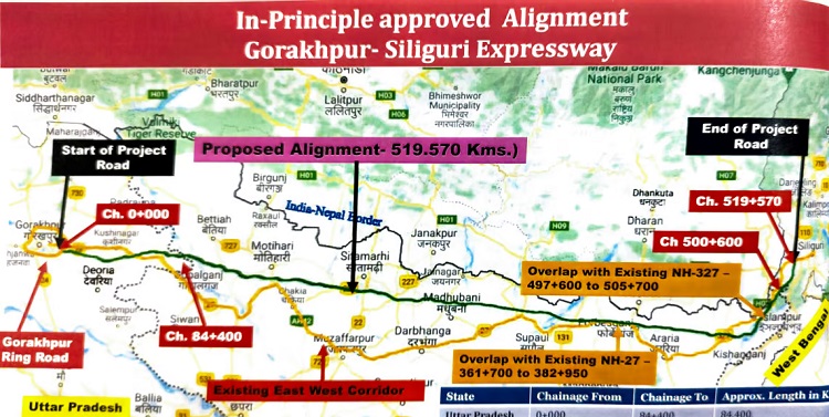
519 km Gorakhpur – Siliguri Expressway by NHAI is a proposed 4 lane access-controlled highway with a route alignment connecting Gorakhpur in Uttar Pradesh and Siliguri in West Bengal.
This greenfield expressway under Bharatmala Pariyojna (BMP) Phase 2 will run parallel to the Nepal Border and connect 3 states of Uttar Pradesh, Bihar (majority) and West Bengal. Land acquisition for its construction started in May 2022.
The expressway is expected to be completed and opened in 2028. Its Detailed Project Report (DPR) prepared by LNM Infra Projects has not been made available online by NHAI.
- Total Estimated Cost: Rs. 32,000 crore
- Project’s Length: 519 km
- Lanes: 4
- RoW: N/A
- Status: Land Acquisition, Detailed Design
- Land Acquisition Requirement: N/A
- Deadline: N/A
- Owner: National Highways Authority of India (NHAI)
- Project Model: Engineering, Procurement and Construction (EPC)
Route Map
An official PDF route map with village list will be added here when available.
The expressway will be connected to the 500 km Bareilly – Gorakhpur Expressway to form one continuous highway.
Around 84 km of the expressway will pass through Gorakhpur, Deoria and Kushinagar districts in Uttar Pradesh. Within Bihar, it will pass through 9 districts of West Champaran, East Champaran, Sheohar, Sitamarhi, Darbhanga, Madhubani, Supaul, Forbesganj and Kishanganj.
Current Status
Land acquisition process for the expressway’s construction started in May 2022.
Tenders & Contractors
This section will be updated when tender notices for its construction are published.
| Package & Chainage | Contractor (Value) |
| Scope Unknown | TBD |
Page last updated: July 8, 2024. Have a question or spot an error? Let me know here.