
Sewri-Worli Elevated Corridor – Information & Status
4.5 km Sewri – Worli Elevated Connector (SWEC) project by MMRDA is an under construction 4 lane access-controlled urban highway with a route alignment connecting Worli, Parel and Sewri in Mumbai, Maharashtra.
This elevated road is under construction by J Kumar Infraprojects (JKIL) and will connect the operational 21.8 km Mumbai Trans-Harbor Link (MTHL) and Worli Seaface close to where the Bandra-Worli Sealink, part of the Mumbai Coastal Road project, terminates.
The project’s bhoomi poojan was conducted in January 2021. It is expected to be completed and opened in late-2025. The project’s Detailed Project Report (DPR) has not been made available online by MMRDA.
- Total Estimated Cost: Rs. 1286 crore
- Project’s Total Length: 4.5 km
- Lanes: 4
- Status: Under Construction
- Deadline: 2025-end
- Owner: Mumbai Metropolitan Region Development Authority (MMRDA)
- Project Model: EPC (Engineering, Procurement and Construction)
Current Status
This elevated road is under construction by J Kumar Infraprojects since 2021 and is expected to be opened in late-2025. Piers for its elevated deck have started appearing along its route with piling work underway at other locations.
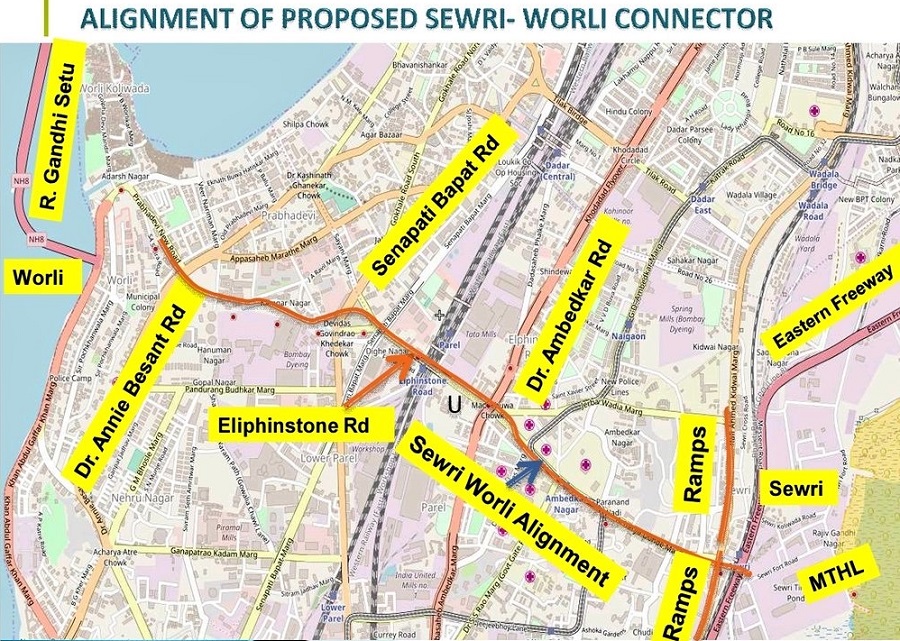
Route Map & Design
The project’s alignment through Mumbai is city is complicated and involves the rehabilitation of 800 families from 1,100 slums in Worli’s Kamgar Nagar.
Its alignment at Sewri starts at the Eastern Freeway from where it will cross the railways’ Harbour Line, pass over RA Kidwai Road and Acharya Donde Marg, cross above the existing flyover at Ambedkar Road, Elphinstone bridge in Parel and flyover at Senapati Bapat Road and then make its way through Kamgar Nagar and Dr Annie Besant Road to terminate at Narayan Hardikar Marg.
The project includes two rail overbridges (RoB) at Sewri and another two-tier bridge at Prabhadevi. The latter crosses the Central Railway and the Western Railway lines.
An official PDF route map will be added here when available. Until then, here’s a grainy map taken from a slide show:
Page last updated: July 7, 2024. Have a question or spot an error? Let me know here.