
Miami – Dade County Metro – Information, Route Map, Fare & Timings
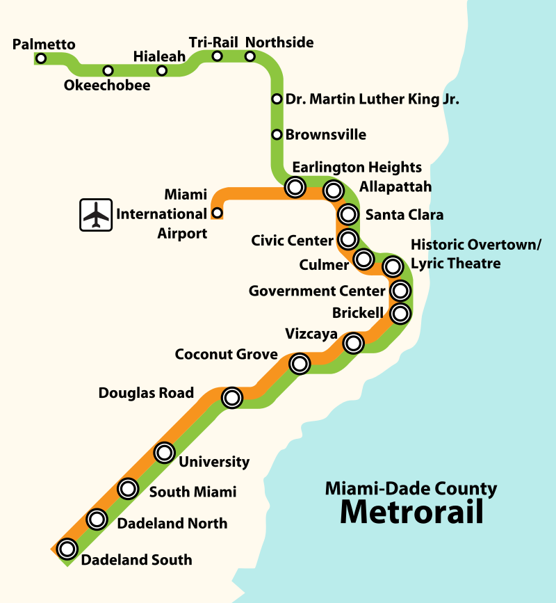
Miami Metro is a 39.3 km metro system with 2 lines (Green & Orange) and 23 stations in Miami-Dade County, Florida, United States. There are currently no plans for extending or building new lines.
Metrorail System Information
- Owner: Miami-Dade Transit
- Operator: Miami-Dade Transit (MDT)
- Total Planned Network: 39.3 km
- Operational Network: 39.3 km
- Operational Stations: 23
- Operations Began: May 20, 1984
- Rolling Stock: Hitachi
- Track Gauge: Standard Gauge (1,435 mm)
Metrorail Lines (Operational Network)
Orange Line: Dadeland South – Miami International Airport
- Stops/Stations: 16
- Stations: Miami International Airport, Earlington Heights, Allapattah, Santa Clara, Civic Center, Culmer, Historic Overtown/Lyric Theatre, Government Center, Brickell, Vizcaya, Coconut Grove, Douglas Road, University South Miami, Dadeland North, Dadeland South
Green Line: Palmetto – Dadeland South
- Stops/Stations: 22
- Stations: Palmetto, Okeechobee, Hialeah, Tri-Rail, Northside, Dr. Martin Luther King Jr. Plaza, Brownsville, Earlington Heights, Allapattah, Santa Clara, Civic Center, Culmer, Historic Overtown/Lyric Theatre, Government Center, Brickell, Vizcaya, Coconut Grove, Douglas Road, University South Miami, Dadeland North, Dadeland South
Miami Metrorail Route Map
An official PDF map will be added here when available
Source: Howchou
Miami Metrorail Ticket Prices (Cost / Fares)
- Metrorail. Fare: $2.25
- Discount Fare: $1.10
To ride, you can pay directly at the fare gate with contactless payment or you can purchase an EASY Card or EASY Ticket, or a mobile pass on the GO Miami-Dade Transit app. Fare gates do not accept cash.
Miami Metrorail Schedule (Timetable)
Metrorail operates 5 a.m. to midnight seven days a week.
Page last updated: January 15, 2025. Spot an issue? Let me know here. View information on other metro systems around the world here.