
Delhi Metrolite’s Geo & Topo Survey Contracts Awarded
Significant pre-construction activity took place last month for the development of the new 19.15 km Kirti Nagar – Bamnoli Village (Dwarka ECC) Metrolite line in south-west Delhi with the Delhi Metro Rail Corporation (DMRC) opening financial bids from local surveying firms for conducting geotechnical investigation, topographical survey and utility identification works along the line’s alignment.
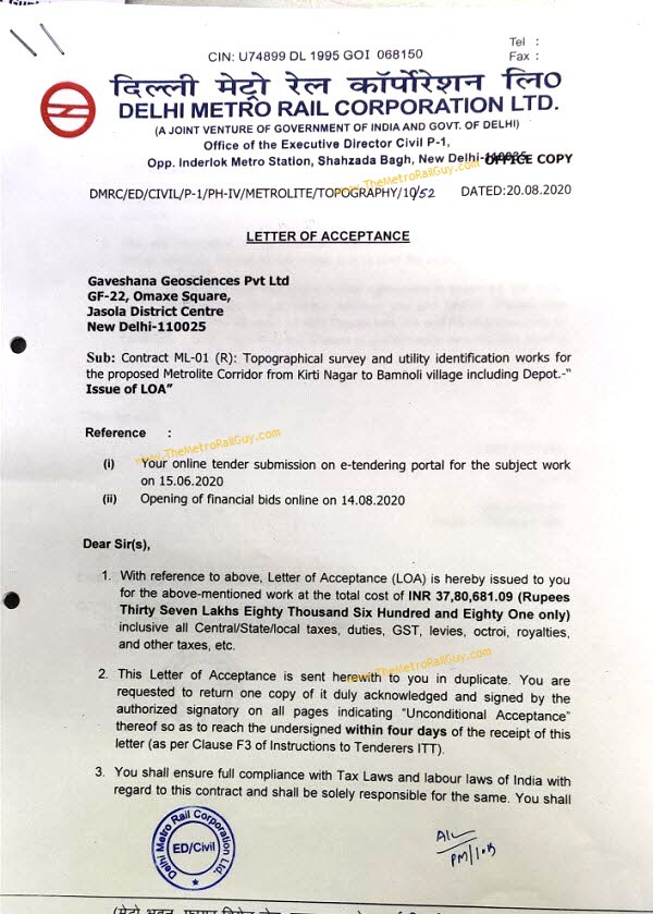
Back in May, DMRC had reinvited bids for this new light rail transit (LRT) system’s topographical survey and utility identification contract (Package ML-01(R)) with an estimate of Rs. 65.73 lakh and completion period of 9 months. They opened technical bids on July 15 to reveal 9 bidders, opened financial bids on August 19, and then issued a letter of award to the lowest bidder, Gaveshana Geosciences Pvt Ltd., the next day with a contract value of 37.80 lakh.
DMRC in May also invited bids for the Geotechnical investigation contract (Package ML-02) with an estimate of Rs. 83.46 lakh and completion period of 4 months. They opened technical bids on July 30 to reveal 9 bidders, rejected 3 firms in the technical round, and then opened financial bids on August 21 to reveal that TechPro Engineers Pvt. Ltd. had placed the lowest bid at Rs. 68.08 lakh. Per an industry source, an LoA for this tender will be issued this week.
Metrolite trains on this line will run mostly at-grade (ground level) on dedicated / fenced-in corridors and act as an excellent feeder to the Delhi Metro system with interchanges planned at Kirti Nagar (Green Line), Mayapuri (Pink Line), Dabri Village (Magenta Line) and Dwarka Court (Blue Line).
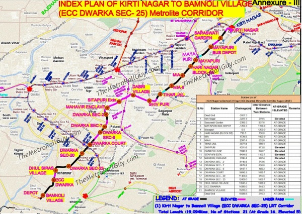
The Kirti Nagar – Bamnoli (Dwarka ECC) metrolite line will consist of 21 mostly at-grade stations at Kirti Nagar (elevated), Saraswati Garden, Mayapuri Bus Depot, Mayapuri, Hari Nagar, Mayapuri Industrial Area (MIA), Mayapuri Industrial Area 2 (MIA 2), Tihar Jail, Shivpuri (elevated), Dabri Village (elevated), Sitapuri (elavated), Mahavir Enclave (elevated), Dwarka Sector 2, Dwarka Sector 7, Dwarka Sector 6, Dwarka Court, Dwarka Sector 20, Dwarka Sector 23, Dhul Siras – Dwarka Sector 24, Dwarka Sector 25 – ECC Centre and Bamnoli Village
The Detailed Project Report (DPR) for this LRT line was approved by the DMRC’s board in October 2019 with an estimate of Rs. 2,673 crore and is currently awaiting the Delhi government’s approval. Whenever that comes in and funding is secured, the DMRC will then invite bids for the line’s civil construction work with the findings from the above 2 service contracts included within the tender documents.
Bids for the design, supply and maintenance of 29 3-coach standard gauge Metrolite trains for up to 15 years were invited in early January 2020. The last date to submit bids for it has been extended at least 5 times and currently stands at November 20, 2020.
For more updates, check out the Delhi Metrolite section of The Metro Rail Guy!
– TMRG


it is 29 3 coach trains I guess
Because it’s a Metro Lite, I guess that the Alstom trains will be use as Alstom is the best metro lite manufacturer, but since it’s DMRC, I m pretty sure that the Hyundai Rotem Trains will be use.
All depends who is going to finance this project.
Thanks – have updated. Original tender notice (linked above) said 22.
Will the metro lite trains run at grade other than elevated,at road level I mean?
For most of route length, they would run at grade. However at some places if the roads are no wide enough, they would go elevated or underground in just like an underpass. Stations would be either at grade or elevated.
Thank you
Topographical Survey Company In Marathahalli. Topographic map surveys are carried out to measure land surface features and levels at the project site for various purposes such as urban and regional planning, design of road and utility lines projects, site preparation (leveling), volumes and quantities calculations. This is for topographic maps of various sizes, scales, and formats according to the purpose for which the maps are used. Topographic data collection can be done using traditional survey systems or satellite positioning systems. The details, accuracy, and location conditions and limitations of the project schedule often determine the type of system and the spatial technology used, and both methods (conventional or satellite positioning systems) have nearly identical results and can therefore be used. We at Scon design Survey Company realize the importance of topographic data for our clients, as this data is considered as one of the vital inputs in the various stages of designing and planning the project. Supervising it by a team of specialists in charting and site surveys, and most importantly, ensuring accuracy and quality throughout the project. All outputs undergo various tests according to the highest recognized professional standards. Company has a balance of an area of many survey projects Tabgrave and topographic mapping for various engineering and planning purposes. Our list of featured projects includes some examples from the topographic mapping work we have done. When performing a topographic survey of a site. As Scondesign experts say, the survey is conducted with permission from the Architectural Department or the Cadastral Service. In its absence, the survey results will not be accepted for approval. If a topographic survey is conducted for the construction of a private house, cottage, cottage, or any other personal needs, then work permission is not required. http://www.sconsurveys.in/our-services/civil-engineering-companies-bangalore/survey-companies-bangalore/topographical-survey-companies-bangalore/