3 Bidders for Delhi-Amritsar High Speed Rail’s Alignment Design
3 design and engineering firms today submitted bids to prepare the final alignment design including an aerial LiDAR survey for the Detailed Project Report (DPR) of the 465 km Delhi – Chandigarh – Amritsar High Speed Rail (DAMHSR bullet train) project in Delhi, Haryana and Punjab.
LiDAR survey is a laser-based surveying technique for rapid and accurate collection of topographic data, and similar surveying works commenced a few weeks ago for the 865 km Delhi – Varanasi High Speed Rail (DVHSR Bullet Train) corridor’s alignment.
The National High-Speed Rail Corporation Limited (NHSRCL) invited bids for this service on December 4 with a completion period of 150 days and estimated cost of Rs. 10.20 crore.
Lead Bidders:
- Aarvee Associates Architects Engineers Consultants Pvt. Ltd. (likely in a JV with GSL Associates Pvt. Ltd.)
- Monarch Surveyors and Engineering Consultants. Pvt. Ltd.
- RITES Ltd. (likely in a JV with Geokno India Pvt. Ltd.)
Package: NHSRCL/CO/CA/LIDAR/2020/44
Scope: Final Alignment design including Aerial LiDAR survey and other related works for DAMHSR
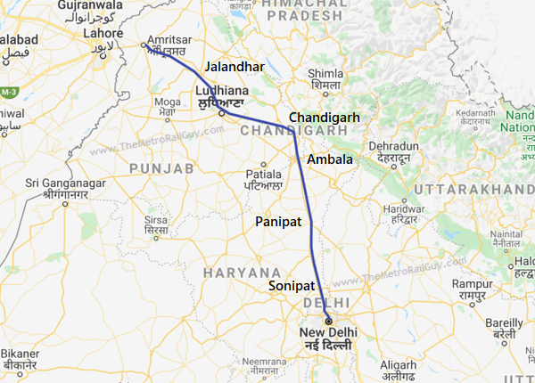
Below is an indicative alignment of the line. A more recent tender notice mentioned stations are planned to come up at Delhi, Asaudha, Rohtak, Jind, Kaithal, Sangrur, Malerkotla, Ludhiana, Jalandhar, Amritsar with a spur line to Chandigarh starting at Sangrur with 3 stations at Patiala, Rajpura and Chandigarh.
The bids have now been sent for technical evaluation which can take up to a month to complete. When that is done, the financial bids of the technically qualified bidders will be opened to reveal who’s the lowest bidder and most likely contractor for this service.
Scope of Works
Final Alignment Report – Detailed Final Location Survey and Studies with final alignment design:
The contractor shall further refine the alignment in the selected alignment corridor by undertaking detailed Final Location Survey using Aerial LiDAR technology along with establishment of Ground Control Network, Pillar fixing, Hydrological Survey (wherever required) and final alignment design (horizontal as well as vertical). For doing this, the contractor shall undertake the following:
Aerial LiDAR & Imagery Survey:
The contractor will undertake Aerial LiDAR Survey complemented by Aerial Imagery in a corridor width of 300 m (150 m on either side) around the proposed alignment. Detailed Specifications are provided in TOR and Broadly the work will involve the following:
- Collection & paper study of existing alignment reports, data, drawing, documents, ground control points etc;
- Ground Control Survey to be undertaken as follows:
- Carrying out reconnaissance survey of the project area for identifying the Control Points locations for carrying out DGPS survey and preparing a plan of a grid network of Control Points on SOI topo-sheets/satellite imagery.
- Survey of India Benchmarks to be located during the above reconnaissance survey. These benchmarks shall be tested for stability and the same shall be reported to the client. The entire horizontal and vertical control shall be linked to the approved stable Benchmarks for conversion of LiDAR data to MSL.
- Master Control Network comprising of interconnected triangles (with baseline of about 25km) to be established for overall horizontal control with approx. 25 km baseline length throughout the alignment. Secondary Control Network comprising of interconnected triangles weaved with Master control network to be established with a baseline length of approx. 3-5 km throughout the alignment. Target LiDAR points to be established at an interval of approx. 5 km within the final alignment. To densify Horizontal Control Network, the GNSS triangulation method should be adopted and processing of data for network adjustment should be done to achieve an accuracy of at least 1:100,000 in horizontal.
- Establishment of vertical control referenced to SoI MSL Permanent Benchmarks to be undertaken by double tertiary leveling along the entire route by connecting target points. The threshold limit for levelling loop closure accuracy should be 12√K mm, where K is circuit length in km.
- Monumentation of Master and Secondary Control Points shall be undertaken if required in consultation with client as per Section 3.3.2
- Applying to DGCA/Ministry of Defence for flying permissions as per DGCA guidelines and procedures along with adherence to all security stipulations issued by Ministry of Defence in the issue of the permit. NHSRCL will provide the necessary support.
- The contractor will mobilize an aircraft/helicopter to site fitted with state of art Aerial LiDAR and Imagery sensors (equipment as per minimum specification mentioned in Annexure 3) after due security inspection as per MoD stipulations.
- Preparation of flight plan for the Area of Interest.
- Acquiring and pre-processing LiDAR data and digital imagery with LiDAR collected at a point density of 10 points per sq m with FHA (Fundamental Horizontal Accuracy) of 10 cm and FVA (Fundamental Vertical Accuracy) of 10 cm both at 95% confidence interval level. Imagery is to be taken at a resolution of 10 cm GSD.
- Pre-processing data to be referenced to MSL with SoI permanent benchmarks.
- Ground survey/Hydrological survey using traditional methods such as Echo Sounders etc along areas such as river crossings etc where Aerial LiDAR data needs to be complemented, including the following:
- 4 km (2 km on each side of centerline) along all river crossings with river cross-sections soundings (or alternate acceptable method) taken at centerline and then at every 500 m distance along upstream and downstream of the river and upto 50 m beyond high bank
- The DEM generated from this data shall be suitably merged with the LiDAR DEM in consultation with the client.
For more updates, check out the High Speed Rail section of The Metro Rail Guy!
– TMRG


lmao. are they mad???
Delhi panipat chandigarh route was more suitable than this potpourri
Delhi panipat route will already have rtgs.No point of having mutiple train routes.
Does these companies have xperience in lidar survey
They have tie-ups with those that do. Aarvee is likely with GSL associates and RITES is likely with Geokno India. I’ve now added a blurb on this next to the names.
Even this suggests Central Haryana route – https://www.railpost.in/delhi-chandigarh-amritsar-high-speed-rail-nhsrcl-floats-tender-for-dpr-prep-work-route-and-station-details-inside/
Cool. Think they’re referring to the same tender notice.
Delhi, Aasaudha (Bahadurgarh), Rohtak, Jind, Kaithal, Sangrur, Malerkotla, Ludhiana, Jalandhar, Amritsar —-> the alignment leaves Delhi towards West / NW and then goes up North. Some section of HSR alignment may fall on the RoW of the planned Delhi-Amritsar-Katra Expressway. The alignment is greenfield and land acquisition will be easier.
This goes without saying that some of the major economic centers / industrial towns of Haryana like Sonipat, Panipat, Karnal, Kurukshetra, Ambala will miss out from being on the HSR; which in itself is not such a big cause of worry. These towns become economic hubs simply because GT Road passed through them (with the possible exception of Kurukshetra which is a religious/pilgrimage city in itself). As the new Expressway and the possible HSR passes through Rohtak, Jind, Kaithal, Sangrur – they would also become new centers of economy, driving growth.
I think Kaithal-Patiala-Ludhiana main line would be better option than having Kaithal-Sangrur-Malerkotla-Ludhiana. Alternatively, Kaithal-Patiala-Chandigarh spur (instead of Sangrur-Patiala-Chandigarh spur)…
Some questions:
– In this arrangement Delhi-Chandigarh follows a semi-circular route. Would it still be possible to reach Delhi from Chandigarh in 1 hr flat?
– What would be the future for the planned RRTS from Delhi to Rohtak via Bahadurgarh (Aasaudha)? Would it be scrapped (OR merged with the HSR)?
Nice analysis. A new route is definitely welcome for growth, otherwise we’d be putting 3/4 key N-S transit routes (NH44/RRTS/HSR) in the same general area. Has major security implications as well.
1. I believe 1 hour could be possible via the express service that skips local stations. So something like: Chandigarh – Sangrur – Rohtak – Delhi. Add station dwell time, acceleration/deceleration and things could get tight.
2. Curious to see what NCRTC is now thinking. IMO, the areas in between Delhi-Rohtak need both. RRTS is primarily geared for daily commuters as you know, so a regular RRTS line with stations ~5-6 km would better serve that purpose.
“lid” in punjabi is adequate to describe anything concerning hsr route that leaves out chandigargh {twin-state-capital with af base and international port
Punjab Zindabad! Hope the protesters see the good development central government is doing for the state. Hope they end this paranoia of the center.
Land acquisition is also a issue in Punjab just like Maharashtra. Farmers are not ready to give land for delhi katra expressway in jalandhar and ludhiana. Why they give kand for hsr. State government also doesn’t cooperative with centre
This will do wonders for the Punjab economy. Tired of seeing exodus of youth to foreign countries due to lack of opportunities.
Is the route is already final ?