LiDAR Survey Begins for Delhi – Varanasi High Speed Rail
With calibration testing completed on Saturday, Aarvee Associates Architects Engineers and Consultants Pvt. Ltd. – GSL Associates Pvt. Ltd JV today started light detection and ranging (LiDAR) survey work to help finalize the alignment of the 865 km Delhi – Varanasi High Speed Rail (DVHSR Bullet Train) corridor in Delhi and Uttar Pradesh.
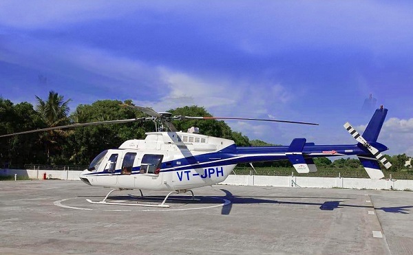
The LiDAR surveying method involves using laser enabled equipment mounted on a helicopter, and for this Aarvee and their subcontractors will be using a 7-seater 2006 Bell 407 registered as VT-JPH.
In November, they received the Ministry of Defence’s approval to operate subject to the compliance of strict conditions. Per my industry sources, only Indian pilots will be allowed and the data obtained from the survey will first have to be vetted and cleared by various national security and intelligence agencies.
The contract for this survey, to help prepare the line’s Detailed Project Report (DPR), was awarded to Aarvee – GSL JV in August with a value of 7.92 crore and completion period of 150 days after they emerged as its lowest bidder among 4 firms.
Here’s a a nice news video shared by the National High Speed Rail Corporation Ltd. (NHSRCL). Watch out for my map (22 seconds in) they’ve used within the report:
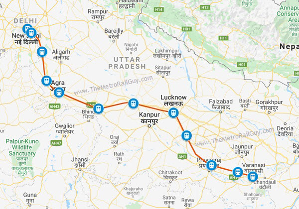
This new high speed rail line will connect both cities through 12 stations in Delhi and Uttar Pradesh. Tentative stations on this line provided by NHSRCL in the past include – Delhi, Noida, Jewar, Mathura, Agra, New Etawah, South Kannauj, Lucknow, Raibareli, Prayagraj (Allahabad), New Bhadoi, and Varanasi.
The final alignment and stations (numbers and location) will be decided in consultation with the government.
Some tid-bits from NHSRCL’s press release last week:
The alignment or ground survey is a crucial activity for any linear infrastructure project as the survey provides accurate details of areas around the alignment.
This technique uses a combination of Laser data, GPS data, flight parameters and actual photographs to give accurate survey data. Based on the findings of the survey, designing of the vertical & horizontal alignment, structures, location of the stations and depots, Land requirement for the corridor, identification of project affected plots/structures, Right of Way etc. are decided.
Similar LiDAR work will be performed by RITES – Geokno JV for the 886 km Delhi – Ahmedabad High-Speed Rail and by SECON Pvt. Ltd. for the 741 km Mumbai – Nasik – Nagpur High-Speed Rail lines in the coming months.
The results from Aarvee’s LiDAR survey and other survey / design work will go into preparing the first draft of the Delhi – Varanasi HSR project’s DPR.
That first draft can take 6 – 12 months to get ready, its finalization can take a similar time, and after that the DPR will go through the regular motions of getting vetted and placed for approval before the NHSRCL’s board, Delhi & Uttar Pradesh state governments’ cabinet, and finally the Central Government’s cabinet. When that final approval comes through, the project’s formal deadline and funding sources will be revealed.
For more updates, check out the High Speed Rail section of The Metro Rail Guy!
– TMRG

Very cool. Would you know where it will make pit stops for refueling and end of day halts?
Nope. I wonder if it can be tracked on FlightRadar24? I’ve sometimes seen helicopters on it, but it all depends on whether it has its transponder on.
“ Aarvee Associates Architects Engineers and Consultants Pvt. Ltd.”
That’s a mouthful 😜
Yup, they def need to shorten it. Just Aarvee is good enough.
As per my sources, pm Modi keen to start bullet train between ahmedabad and vapi by 2024 at any cost.
Completion of ç4 package is 5 years timeline. That’s 2025 already. On the top, trials and clearances.
Maybe change your sources…
No reason to be rude.
So, by the mid 2021, we will have the basic reports (lidar, surverys) completed? If so, I guess we are looking at the DPR by end 2021?
Yup, 2021-end for 1st draft sounds about right
TMRG, is JKumar and NCC have awarded a contract for Line 2B balance civil work?
Naah, not yet. Whenever awarded, we’ll first hear it from J Kumar at the BSE.
Is it true that Delhi-Varanasi bullet train route will be through Ayodhya? & And than this line will extend from Varanasi to Kolkata?
Recent TOI report (which got copied by others) mentions connecting Ayodhya but that does not cite any sources or even NHSRCL which is quite active in publishing press releases. Let’s see what the DPR says when prepared.
Yup, this line will eventually connect to Howrah in Kolkata. NHSRCL recently invited bids for two survey-related work which includes this extension. See: https://themetrorailguy.com/2020/12/05/nhsrcl-invites-survey-bids-for-2365-km-of-high-speed-rail-lines/
I’m hearing this for the first time. As someone who is from Ayodhya, this would be wonderful. But I wonder what the alignment would look like in that case and whether it would even be feasible.
TMRG,
– What’s the width of the corridor that is being surveyed? I mean is it 1km wide corridor or 5kms wide or more/less? NHSRCL must have defined the the Survey Scope of Work; which means, the planners of NHSRCL must have drawn up a tentative alignment (possibly using the Survey of India charts)…but is that info available in public domain?
– Will Kanpur be on-route OR off-route?
– I don’t think the alignment can be diverted enough to make the route pass through Ayodhaya – that TOl report is more of a hearsay
Not sure about Ayodhya comment: the govt can go for it if there is enough returns for it according to the travel surverys. Otherwise, same could be said for Patna in Varanasi-Kolkata corridor, where the straight line is Varanasi, Aurangabad, Rachi, and so on…
Why not to use drones for the lidar purpose ? Cost would have been much reduced.
Nice idea. But LIDAR survey requires lots of heavy equipment which is currently not possible in Drone. Also, Drones have a limited range. That is the main reason why engineers use helicopters or small planes for LIDAR Survey.