ADB Reveals Bangalore Metro Airport Line’s Design Details
The updated website of the Asian Development Bank (ADB) reveals many interesting design and civil construction details on Bangalore Metro’s proposed Line-5 (Blue Line) which will link Bengaluru’s Kempegowda International Airport to KR Puram Station as part of the 37 km Phase 2B with 17 stations.
Bangalore Metro Rail Corporation Ltd (BMRCL) has been in talks with ADB for a USD $500 million (approx. Rs. 3,760 crore) loan since 2018 to finance the construction of its new 56 km Line-5 (Silkboard – Bengaluru Airport) which will be developed in parallel in Phase 2A (Silkboard – KR Puram) with 13 stations.
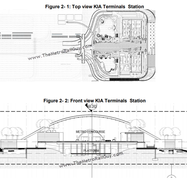
ADB’s advance contracting notice posted in October 2019 had earlier revealed both stations at the airport, Sky Garden and KIA Terminals, will be built at-grade. Per ADB’s updated site, KIA Terminals Station will be now be partially underground.
Design Details
Note: Italics text is my commentary and bolded text is my emphasis
• Design Speed – The maximum sectional design speed will be 90 km/h. Simulation studies of alignment, vertical profile and station locations will be used to determine the applied cant, and length of transition in relation to normal speeds at the different locations to minimize wear on rails on curves.
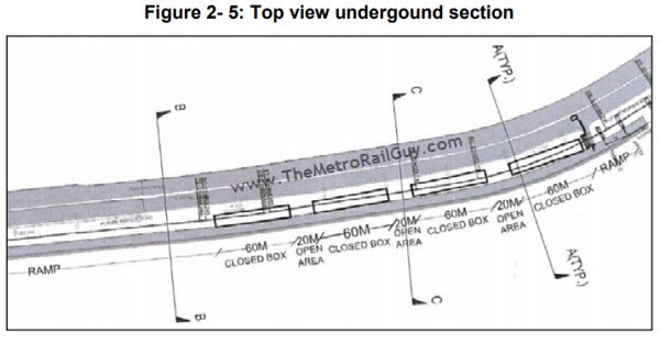
• A 300 m long section near the Yelahanka Air Force Station will be constructed underground through a cut and cover section. This was reported back in August 2017 and is nothing new.
• A new train maintenance depot is planned to be built near Doddajala Station, right next to the Devanahalli Toll Plaza near the trumpet interchange at the airport’s entrance.
• There is a proposal for switch-over of Baiyappanahalli depot from E-W corridor to ORR corridor by remodelling it. This also proposed to augment stabling capacity at Baiyappanahalli depot from the existing 16 lines to 42 lines to cater to complete operational needs of Phase 2A ORR line and partial requirement of Phase 2B Airport line. Considering the augmentation plan at Baiyappanahalli, the construction of the Airport depot facility is proposed in two phases. In the first phase 12 stabling lines will be constructed and a combined shed with 4 inspection lines and 2 repair lines and pit wheel lathe PWL line by the year 2023. In the second phase, two more repair lines and test track of 750 m length shall be constructed. The balance O&M requirement for this section will be supplemented by the facility at Baiyappanahalli depot.
• A linking line starts from the existing ramp of phase-2 Reach-1 extension at Baiyappanahalli as ‘Y’ junction after crossing railway line connects the proposed Airport line at ORR after the flyover. Two pocket tracks of 250m (near Yelahanka station) and 200m (between Veeranapalya and Kempapura stations) length are planned for turn back, emergency stabling facilities and operational convenience.
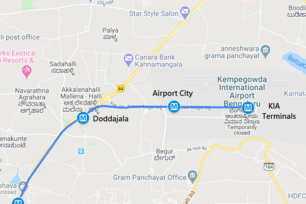
• Horizontal Alignment (view map) – The proposed metro alignment starts after Jyothipuram station of Phase 2 (R1- Extension) as an extended corridor of Phase 2A (Central Silk Board to KR Puram), then it turns right and follows the ORR on the left side of existing flyover and joins ORR median at Kasturinagar. Further alignment will generally follow median of the ORR up to Kempapura station. After Kempapura station, the alignment takes right turn to enter Hebbal bus depot area where Hebbal station is located and reaches NH-44 before Kodigehalli station and further continues till Doddajala on the 5m wide strip of land reserved for high speed rail
corridor between main road and service road on NH-44. Before Doddajala station, the alignment takes a right turn and moves parallel to railway line for a short length after crossing the railway line and takes a right turn to reach airport road median and continues along the road median up to KIAL boundary. After KIAL boundary, the alignment takes left turn and continues off road up to KIA terminal station. The road alignment is fairly straight without sharp curves and the metro alignment is planned with minimum radius of the horizontal curve as 127.50 m
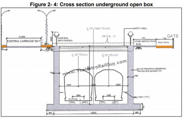
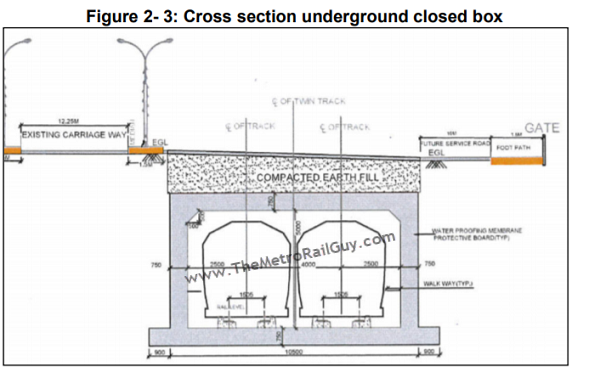
• Vertical Alignment – Track supporting structures on elevated sections are to permit a vertical clearance of 5.50m above road level for movement of vehicular traffic. To meet this requirement with the box girder/ U-girder design and construction of an elevated pedestrian walkway below the viaduct, the rail level is planned to be generally 13.5 m above the road level. This will also permit construction of elevated pedestrian walkways and footbridges (connecting bridges) for platform interchange for commuters at stations below the viaduct. Between Yelahanka Station and Bagalur Cross Station a section of the alignment will be constructed underground in order not to interfere with the operations of the Yelahanka air force station. The construction will be a combination of closed and open boxes with a depth of 8.25 meter and a width of 10.5 meter length of the underground section will be 300 meter excluding ramps
• The most widely used precast segmental box girder with post tensioning superstructure was selected for the viaduct of this project considering ease of construction and standardization of the formwork for wide span ranges. Earlier they were going to use U-girders (see example) to build the line.
• Total of 17 stations are proposed along the Phase 2B line and 7 stations out of 17 stations have been planned for commercial development for an area of about 1000 sqm at each station at concourse level. The area at ground level will be used for intermodal transit and parking.
• Provision of 6m wide service road has been proposed around the stations for integration with BMTC buses to ensure last mile connectivity for commuters. It is also proposed for construction of Metro Rail Depot Structures, site development works, internal roads and drainage works in the depot at Baiyappanahalli and near KIA.
• The line will be split up into 5 civil packages of which 4 (detailed below) will be designed and built by BMRCL’s contractor, and 1 within the airport’s premises by Bengaluru International Airport Limited (BIAL) which will integrate the line’s corridor with its under construction Terminal 2’s design.
A map of the line with stations marked can be viewed here.
Package P1
- Scope: Construction of elevated structure (Viaduct & Stations) from KR Puram to Kempapura Cross Metro Station (includes 281 m. of Viaduct beyond Phase-2A and 650 m of link line connectivity to Baiyappanahalli), road widening, utility diversion and allied works.
- Length: 11003m
- Stations: 8 Nos. of elevated stations viz. Kasturi Nagar Station, Horamavu Station, HRBR Layout Station, Kalyan Nagar Station, HBR Layout Station, Nagawara Station, Veerannapalya Station and Kempapura Station
Package P2
- Scope: Construction of elevated structure (Viaduct & Stations) from Kempapura Cross Metro Station to Bagalur Cross Station including 250 m length of pocket track, road widening, utility diversion and allied works.
- Length: 11678m
- Stations: 5 Nos. of elevated stations viz. Hebbal Station, Kodigehalli Station, Jakkur Cross Station, Yelahanka Station & Bagalur Cross Station.
Package P3
- Scope: Construction of elevated structure (Viaduct & Stations) from Bagalur Cross Station to Kempegowda International Airport including road widening, Utility diversion and allied works.
- Length: 15011m
- Stations: 2 Nos. of elevated stations viz. Bettahalasuru Station and Doddajala Station
Package P4
- Scope: Construction of Metro Rail Depot structures, site development works, internal roads & drainage works in Depot at Baiyappanahalli and near Kempegowda International Airport.
For more updates, check out the Bangalore section of The Metro Rail Guy!
– TMRG

It was better to make this Line as a Airport Express Metro Line instead of normal metro line. As the Airport Express Metro is Faster than normal metro. Also, the Airport Express have less station which may help them to cut down the construction cost. BMRCL should thought about it during planning of this line. TMRG, what’s your opinion about it?
The number of stations planned are fine (17 for a 37 km line) otherwise it be a drag, but they could have designed it for higher (slightly costlier) speeds.
There’s an immediate requirement to service the ORR’s northern section (KR Puram – Hebbal) by a regular MRTS solution, so a station roughly every km there makes sense. As the line moves north along the NH, the distance between adjacent stations moves to 2-3 kms, which is great, and this is where higher speeds would in the future have led to time savings.
Yes, i think ideally it should’ve been normal Metro until Yelahanka and an airport express line from there on with coaches like the Delhi’s airport express line. This would lead to faster commute for airport passengers while also servicing the city upto Yelahanka and keeping costs reasonable
So, there are 3 huge packages for viaduct & station constructions for this 38km line. The other two are for the depot & terminal station at KIA.
Any drawings for depot location & construction? Is it to the north of the road or south? Can see there is empty land on both sides.
No drawings are available. Doc says “Depot which is located on the right side of NH 44 near Trumpet toll plaza”, so that places it in the south-east quadrant of the NH-44-KIAL Road intersection.
A line to the airport should have a catchment all over the city. Wherever you are in the city you should be able to board the airport line within one changeover. The ORR – KIA line is virtually the eastern fringes of the city. Are citizens in that area the only ones to travel by air? For instance someone on the green line has to switch to yellow line at RV, then to the KIA line at SB. Or they have changeover to the purple line at Majestic and then the KIA line at KRPuram. Thats 2 changeovers (apart from being circuitous travel) which certainly passengers with luggage, children, senior citizens would dread. In this present plan majority of the city is bypassed.
Hi Sreeram! I totally agree with your sentiment here. However, do note that the Nagawara will connect with the airport line sometime in 2024… so hold on tight
Their original plan was the Nagwara line going up to KIA. But few years ago it dawned on them that there is a gas pipeline running which could not be crossed. (I dont know the exact locations but I do know that there was lots of debate on this by citizens on the skyscraper website). Thats how this SB-KIA line came to proposed.
Even if the Nagwara line were to be extended, someone on the green line would still face 2 interchanges. Dont think too many from those areas would use the metro to the airport.
HI TMRG
As a layman i am interested to know from you why a gas line cannot be crossed?
Does it mean there can never be any development around gas lines? certainly dont think so- afterall roads, layouts etc. are constructed all around gas lines around the world. Why was such a fuss created in this particular case?
That’s the first time I’m reading about this gas line issue. I don’t believe that’s a valid reason. Rerouting / modifying utility lines is pretty standard in all civil construction packages.
This is high pressure gas Bangalore-Mangalore pipeline. And any heavy construction 9 mtrs on both of it’s sides is not feasible. Building layouts/roads is another story as its mostly surface construction. But building an elevated railway line in its vicinity is a tragedy waiting to happen.
There was also talk of extending the Carmelram- Hebbal metro to Airport. But thats still years away from materializing, though I recently heard (do not know how true it is) that this line has been dropped.
So to provide the connection to the airport at the earliest the ORR was extended.
Any idea why they decided not to use U girders? This line runs along very wide roads so construction space shouldn’t be a constraint…
No idea why. Found it strange, as this line and Line-3 to Electronic City are ideal for U-girders.
Hi TMRG!
A quick question:
For the top view of the metro terminal, where is the train track?
Is it the pathway going around? or is the periphery pathway a walkway for people to enter the platform?
It’s right in the middle – running east to west (left to right). The graphic doesn’t quite show the tracks, just a basic view.
Is there any alignment drawings (pdf?) for this line? Looking for exact station locations along this line.
Exact locations haven’t been revealed yet. Will share if I come across any alignment drawings.
Any update on this?
any update on the Bettahalasuru station, chikkajala station and the station which was planned at the jakkur plantation??